Koke’e State Park via Nu’alolo Valley Trail
7.6 miles – 1,600+ feet
If you are looking for a really tough hike in the Waimea Canyon region, you’ll inevitably get a recommendation for the 11-mile loop on the Nu’alolo, Cliff and Awa-‘awapuhi trails in the Koke’e State Park. We set out to do that very hike early one morning after having beach camped at Polihale State Park (highly recommended).
We were prepared for a strenuous full-day hike. My nerves, however, were not prepared for a somewhat washed out section of the Cliff Trail, where a short, but steep uphill with nothing to grab onto was combined with loose scree and a cliff drop off below. Taking to heart the sign that said to “proceed at your own risk” before the washout, I decided to turn back and make it an out and back instead of a loop.
Was it really that bad? A lot of people make it on the full loop without falling off a cliff; in fact in online reviews many people say it’s not difficult at all. My hiking companion had no trouble going up the incline that turned me away. At the same time, we did see at least one other person who turned back at that point, so I knew I wasn’t alone in my jitters. It’s a personal decision and one that you can reasonably make at that point in the trail.
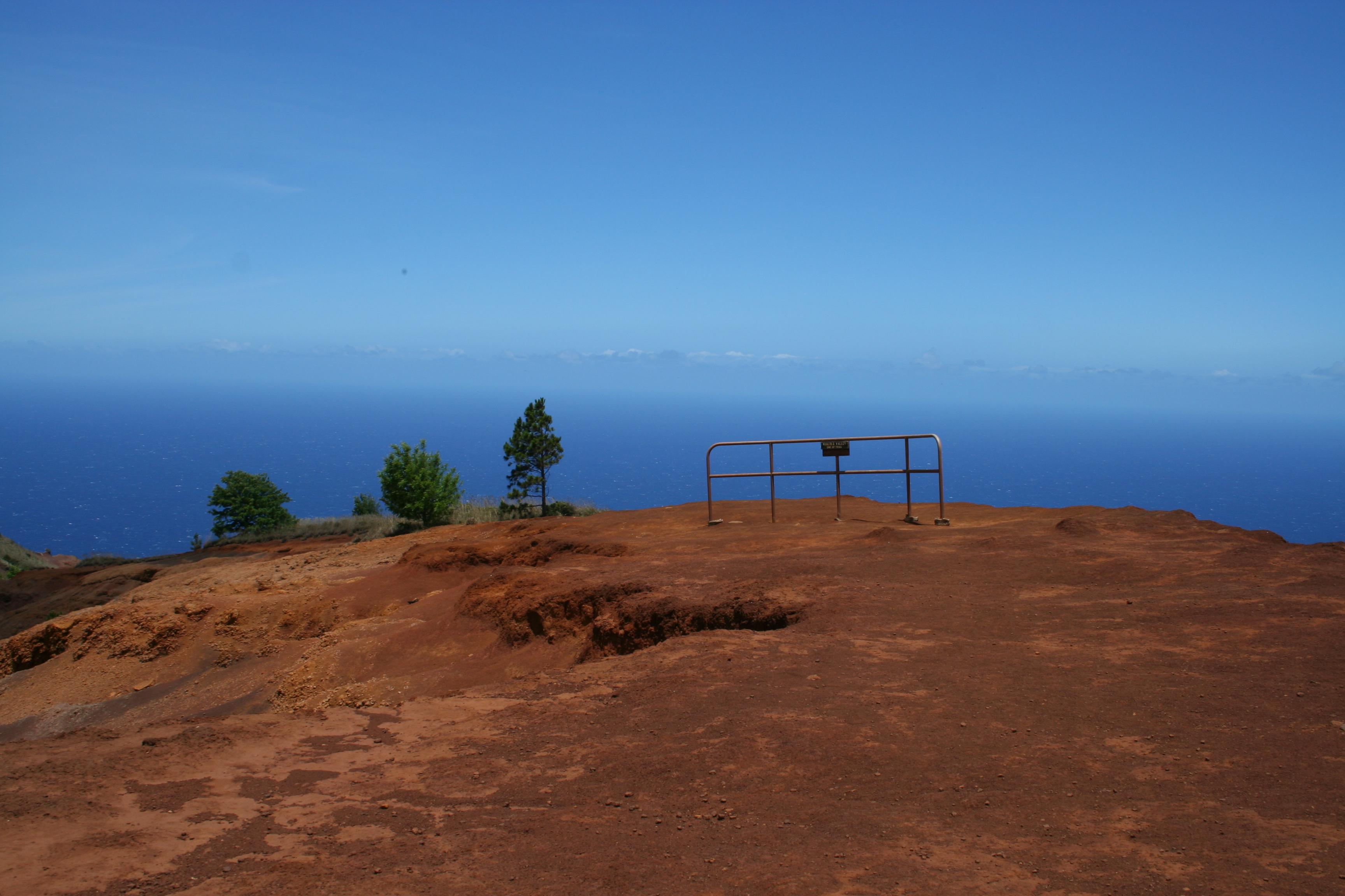
Since we didn’t make the full loop, I’m going to instead describe a shorter out and back option that takes you to what feels like the edge of the world. The hike goes to Lolo Vista, a rocky outcropping with an awe-inspiring view of the northwest shore of Kauai. We did some extra hiking in our pass to attempt the Cliff Trail as well as going to the Lolo Vista lookout twice so we could eat lunch there on the return trip. Because of this, the GPS track is not accurate for a straight out and back. Where possible I’ve tried to provide an estimation of what it would be without the extra hiking we did. Our hike was 9 miles, you should be able to do it as an out and back in approximately 7.6 miles.
| Distance | 7.6 miles out & back 9.0 miles our track |
| | Time | 4.5 hours out & back 5.5 hours our track |
|---|---|---|---|---|
| Elev. Gain | 1,600+ ft. out & back 2,776 ft. our track |
| | Elev. Loss | 1,600+ ft. out & back 2,449 ft. our track |
| Difficulty | Strenuous [?] | | | Parking | Easy [?] |
| Trail Signage | Good [?] | | | Bathrooms | Flushies at start |
The Route
Nu’alolo Trail » Lolo Vista » Nu’alolo Trail
Our Track: Nu’alolo Trail » Lolo Vista » Nu’alolo Cliff Trail » Lolo Vista » Nu’alolo Trail
Trail Maps
- GPS Track: Download the GPX file. Note: This includes our extra distance on the Cliff Trail as well as going to Lolo Vista twice.
- Area trail map: Trails in Koke’e State Park and Waimea Canyon State Park (PDF)
- Trail Brochure: Official trail brochure from Koke’e State Park (PDF)
The Route In Detail:
1. Park at Koke’e Lodge and Museum where you can fill up on water or use the restroom before you hit the trail.
2. Walk south on Waimea Canyon Drive/Koke’e Road briefly to get to the Nu’alolo Valley trailhead on your right.
3. The first part of the trail is uphill, climbing through a relatively dense forest on the sometimes slippery red dirt that you find everywhere on Kauai before heading almost exclusively downhill for the rest of the outward trip. You’ll pass through several different ecosystems including Koa forests, sun-drenched areas of wildflowers and then a dry brush-like terrain with stellar views that just keep getting better.
The trail itself is steep, rocky and root-filled in places. In others you feel like you are hiking through a natural drainage ditch or dry riverbed that surely gets mucky when it rains.
4. Take a left per the sign for Lolo Vista at 3.4 miles into the hike. There are some false trails before this intersection so if you see a turnoff without a sign, disregard it and stick with the main trail.
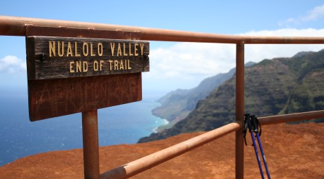
5. From the intersection it is .5 miles to Lolo Vista on a narrow trail along a ridge. The vista itself is a wide rocky point with stellar views of the coast to the north. Just to make sure you know when you’ve reached the official end point, a rather amusing stretch of railing with signage [photo] announces the trail end. This is a great spot to stop for lunch though you may need a jacket if it’s windy since there are no trees to break the ocean breeze.
6. The return trip is along the same route in reverse.
6a. Alternate: If you want to attempt the full 11-mile loop mentioned in the introduction, you would return from Lolo Vista to the previous signed intersection and follow the signage to the Cliff Trail. At about .2 miles from this intersection you will come to the washout area.
Photos


Trail Notes & Tips
Difficulty
This is a strenuous hike with very steep ups and downs, rocky and root-covered terrain, exceptionally narrow stretches and areas of cliff drop-offs to the side of the narrow track. If it’s been raining or wet at all, the red dirt will be slippery adding to the difficulty of the hike. The out is tough on the knees and the back is tough on the quads.
Trail tip: Potable water
The two main lookouts — Waimea Canyon Lookout and Pu’u Ka Pele Lookout — on your drive up Waimea Canyon Drive/Koke’e Road have bathrooms and running water, but the water is not safe to drink. To get water before you hit the trail, you can fill up at the bathroom at Koke’e Museum. A worker there told us to run the water briefly before using it to clear out anything in the pipes, but assured us it was fine to drink.
Getting There
Directions
Here is the Google Map of the trailhead. Parking is just north of it at the Koke’e Museum and Lodge.
From Waimea
- Head north on Waimea Canyon Drive/Highway 550
- Go past the Waimea Canyon Lookout and Pu’u Ka Pele Lookout
- Park at Koke’e Museum and Lodge, just before mile marker 16
Parking
Park in the lot at Koke’e Museum and Lodge. You’ll need to walk a very short distance along the road south (downhill) to get to the trailhead.
Hi, great post. I like the inclusion of an elevation profile in your maps section.
Your readers might be interested in my Kokee & Na Pali Coast recreation map that shows your hike (and all others in NW Kauai) as an iPhone map fro Avenza PDF maps. It combines the detail and quality of a print map with the iPhones GPS and the ability to see your location on the map and record way points along the way.
You find out more here:
http://www.mapbliss.com/MedeCart/KokeeGeoPDF.html
Let me know if you’d like a free copy and I’ll send you a link.
Aloha,
David,
New site for the Koke’e PDF Recreation Map: http://www.mapbliss.com/MedeCart/KokeeTrailMap.html