
Inyo National Forest: McLeod Lake Loop
less than 2 miles – 1025 ft.
The Mammoth high country in the Eastern Sierras (just to the east of Yosemite) offers great camping and hiking away from the national park crowds. This easy hike southwest of the winter ski town of Mammoth Lakes gives you a taste of what the high Sierras have to offer – pristine lakes, amazing oft-snowcapped mountain peaks and jagged rock outcroppings. The hike starts where Route 203/Lake Mary Road ends at Horseshoe Lake in the Inyo National Forest. You’ll ascend through a ghostly forest of white, barren trees killed by carbon dioxide emanating from the earth beneath into the subalpine forest to your destination of McLeod Lake. After spending some time at the lake with the local dog owners and their very happy canines, you’ll climb a little higher before descending back to the parking lot.
This is a high elevation hike, starting at just under 9,000 feet and climbing to just over 9,300 feet at your highest point so snow is a very distinct possibility in the shoulder seasons. The trails and roads in this region generally open Memorial Day weekend, but depending on the snow and possible winter damage the actual date may vary greatly. Be sure to check the official national forest Web site for up-to-date information before hitting the trail.
| Distance | 1.4 miles, plus hiking at lake | | | Time | 1 hour |
|---|---|---|---|---|
| Elev. Gain | 1025 ft. | | | Elev. Loss | 1020 ft. |
| Difficulty | Easy [?] | | | Parking | Easy [?] |
| Trail Signage | Good | | | Bathrooms | At trail start |
The Route
Mammoth Pass Trail » Trail to McLeod Lake » McLeod Lake » Mammoth Pass trail connector » Mammoth Pass Trail
Trail Maps
- GPS track: Download the GPX file
- Area trail map: PDF of regional trails
- Mammoth High Country paper map: Waterproof shaded-relief topographic map of the area for sale
The Route In Detail:
1. Park at the Horseshoe Lake parking area.
2. Follow the signs for the Mammoth Pass Trail that ascends through the barren forest beside the parking lot bathrooms.
3. At the first junction, follow the signs to McLeod Lake to the left. This trail is unnamed on all the maps that I have, but the sign is clearly labelled as “McLeod Lake.”
4. Continue on the trail until you come to McLeod Lake itself in front of you. The GPS track shows coming to the lake, walking around it part way before returning back to the trail. You can, if you want, walk the full circumference of the lake.
5. Go back to where you first saw McLeod lake in front of you and you’ll see a trail junction. Follow the sign for “Mammoth Pass” and “Reds Meadow” uphill. This connector trail will take you to the Mammoth Pass Trail.
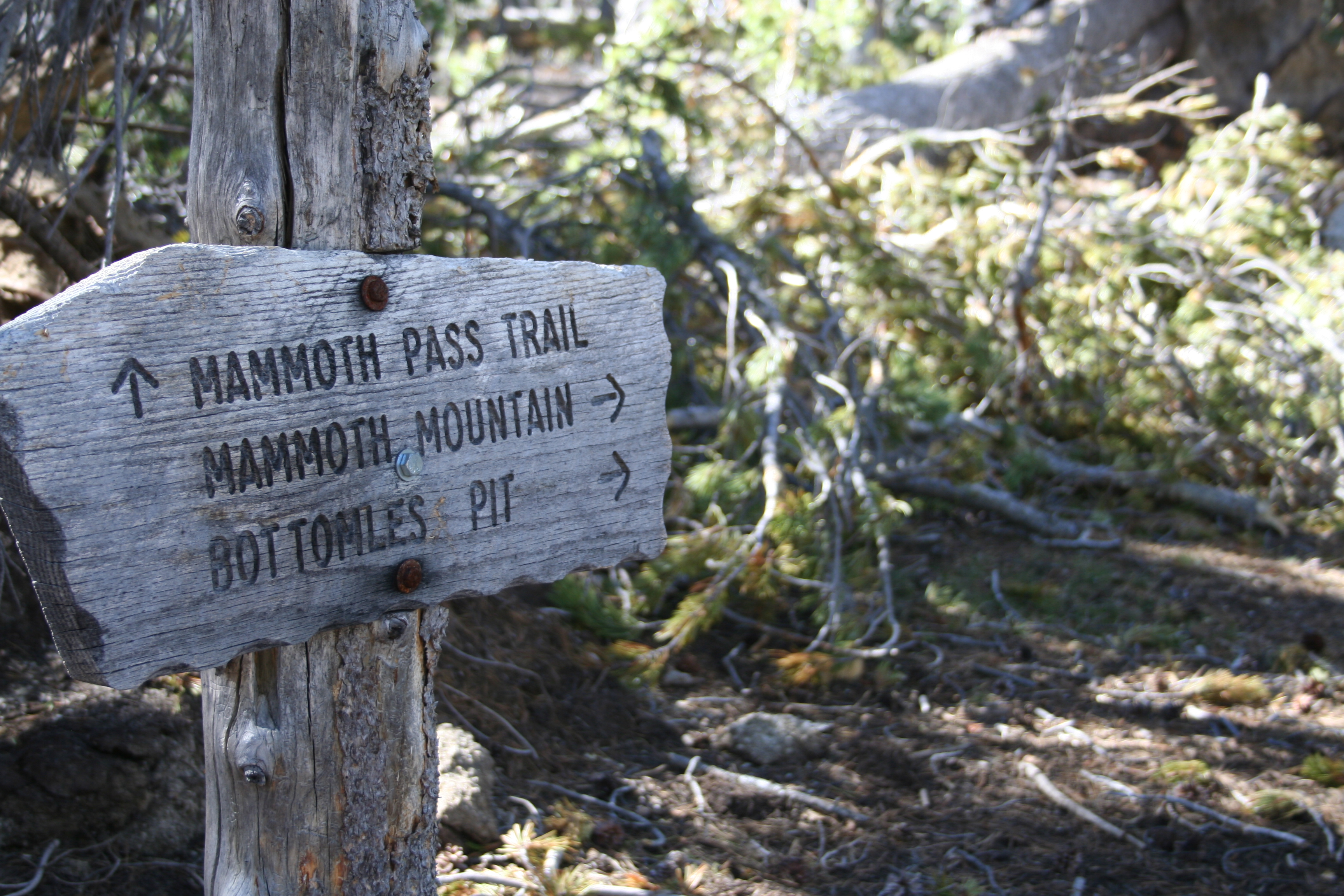
6. At the first intersection, take a right on Mammoth Pass Trail. Note that the trail sign is slightly confusing; it shows Mammoth Pass Trail to your left and Mammoth Mountain and Bottomles [siq] Pit straight ahead, but doesn’t say anything about Mammoth Pass Trail to the right although the trail clearly goes both directions. [Photo of the trail sign]
7. Continue downhill to the parking lot.
Photos


Trail Notes & Tips
Difficulty
This hike does involve some uphill hiking at elevations above 9,000 feet. Having said that, I’d still consider it easy at such a short distance. Take your time; altitude can make you more winded than normal.
Alternative longer and shorter hikes
There are a lot of trails in this region and if you have a good trail map, like this one from Bored Feet Press, you can come up with many different hike combinations in the area. Here are just two alternatives to extend or shorten the hike.
Option 1: Longer version
An easy extension for this hike is to walk the full circumference of McLeod Lake and also add a hike around Horseshoe Lake near the trailhead.
Option 2: Shorter version
If you are looking for a really short hike, making this an out-and-back to McLeod Lake instead of a loop hike will cut the mileage down to a mere 1.2 miles roundtrip.
Trail tip: Know the signs for altitude sickness
Until you acclimate to high altitudes you may find that you feel more out of breath than usual while hiking at elevation and need to move a little slower than normal as your body is getting less oxygen in the air than it is used to. You may also get a mild headache. This is a pretty normal experience for flatlanders who visit high elevation destinations. Having said that, acute mountain sickness (often referred to simply as altitude sickness) can be more serious and even life-threatening. According to the U.S. National Library of Medicine’s PubMed Health database, “Acute mountain sickness is an illness that can affect mountain climbers, hikers, skiers, or travelers at high altitude (typically above 8,000 feet or 2,400 meters)… Symptoms range from mild to life-threatening, and can affect the nervous system, lungs, muscles, and heart.”
Before heading to a high altitude destination, you should know the symptoms and what to do when you experience them. Learn more here.
Getting There
Directions
Here is the Google Map to the trailhead parking
From Mammoth Lakes
- Take Route 203 west to Lake Mary Road (it changes names within the town of Mammoth Lakes)
- Follow Lake Mary Road until it dead-ends at the Horseshoe Lake parking lot
Parking
There is a large parking lot at Horseshoe Lake where Route 203/Lake Mary Road comes to an end.